Title:
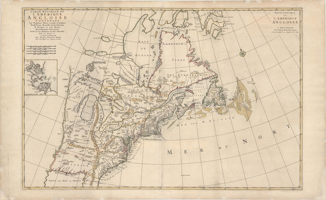
“Carte Nouvelle de l'Amerique Angloise Contenant la Virginie, Mary-Land, Caroline, Pensylvania Nouvelle Iorck, N: Iarsey N: France, et les Terres Nouvellement Decouerte...”
Map Maker:
Pierre Mortier
This large, interesting map is filled with various... (full text available to subscribers)
| Item Detail |
| |
| |
MapMaker: |
Pierre Mortier
|
|
| |
| |
Subject: |
Colonial Eastern United States & Canada |
|
| |
Period/Size: |
1700 / 23.4" x 35.9" (59.5 x 91.2 cm)
|
|
| |
Color: |
Colored
|
|
| |
Condition: |
(B+) A crisp impression with light printer's ink residue at bottom right and several areas of light toning caused by non-archival tape on verso that has since been professionally removed. A few small chips and tears along the edges of the sheet have also (condition help) |
|
| |
Source: |
Suite de Neptune Francois |
|
| |
References: |
Burden #765; Cumming (SE) #129; McCorkle #695.7. |
|
| |
|
|
| Sales Information |
| |
| |
Price: |
|
|
| |
| |
Offered by: |
Old World Auctions |
|
| |
Catalog: |
Auction No. 162 - Antique Maps, Charts, Atlases & Globes (9354) |
|
| |
Lot/Item #: |
117 |
|
| |
| |
Date: |
04/2017
|
|
| |
| |
|
Antique Maps - Valuation and Pricing, Descriptions, Resources |
|
Home |
Information |
Search |
Register |
Contact Us |
Site Map
Americana Exchange, Inc. © 1999 - 2024 Americana Exchange, Inc.. All rights reserved.
OldMaps.com, the OldMaps.com logo and
AMPR are service marks or registered service marks of Americana Exchange, Inc..
|