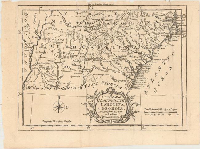
Title:
“A New Map of North & South Carolina, & Georgia. Drawn from the Best Authorities”
Map Maker:
Thomas Kitchin
A charming small map of the southeast with the bou... (full text available to subscribers)
| Item Detail |
| |
| |
MapMaker: |
Thomas Kitchin
|
|
| |
| |
Subject: |
Colonial Southeast United States |
|
| |
Period/Size: |
1765 / 6.8" x 9.1" (17.3 x 23.2 cm)
|
|
| |
Color: |
Black & White
|
|
| |
Condition: |
(A) A dark impression on a clean sheet with a few tiny chips along the top edge of the sheet far from the map image. Issued folding. (condition help) |
|
| |
Source: |
London Magazine |
|
| |
References: |
Jolly #LOND-244; Cumming #348; Sellers & Van Ee #1390; Phillips (Maps) p. 295, 613 & 819. |
|
| |
|
|
| Sales Information |
| |
| |
Price: |
|
|
| |
| |
Offered by: |
Old World Auctions |
|
| |
Catalog: |
Auction No. 162 - Antique Maps, Charts, Atlases & Globes (9354) |
|
| |
Lot/Item #: |
184 |
|
| |
| |
Date: |
04/2017
|
|
| |
| |
|
Antique Maps - Valuation and Pricing, Descriptions, Resources |
|
Home |
Information |
Search |
Register |
Contact Us |
Site Map
Americana Exchange, Inc. © 1999 - 2024 Americana Exchange, Inc.. All rights reserved.
OldMaps.com, the OldMaps.com logo and
AMPR are service marks or registered service marks of Americana Exchange, Inc..
|