Title:
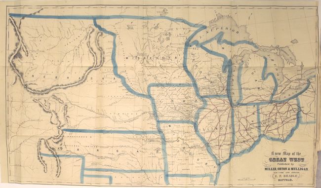
“The States and Territories of the Great West; Including Ohio, Indiana, Illinois, Missouri, Michigan, Wisconsin, Iowa, Minnesota, Kansas, and Nebraskaģ”
Map Maker:
E.F. Beadle
Book illustrated with lovely, engraved views, and ... (full text available to subscribers)
| Item Detail |
| |
| |
MapMaker: |
E.F. Beadle
|
|
| |
| |
Subject: |
Books with maps, Central United States |
|
| |
Period/Size: |
1856 / 7.8" x 5.3" (19.9 x 13.5 cm)
|
|
| |
Color: |
Colored
|
|
| |
Condition: |
() The map has a few small spots of foxing and a 5" binding tear that has been closed on recto with archival tape. A smaller, 1.5" separation is above the closed tear. Narrow bottom margin as issued (B). Text is mostly clean and tight. Covers and spin (condition help) |
|
| |
Source: |
|
|
| |
References: |
Wheat (TMW) #885; Wagner-Camp #274a. |
|
| |
|
|
| Sales Information |
| |
| |
Price: |
|
|
| |
| |
Offered by: |
Old World Auctions |
|
| |
Catalog: |
Auction No. 162 - Antique Maps, Charts, Atlases & Globes (9354) |
|
| |
Lot/Item #: |
211 |
|
| |
| |
Date: |
04/2017
|
|
| |
| |
|
Antique Maps - Valuation and Pricing, Descriptions, Resources |
|
Home |
Information |
Search |
Register |
Contact Us |
Site Map
Americana Exchange, Inc. © 1999 - 2024 Americana Exchange, Inc.. All rights reserved.
OldMaps.com, the OldMaps.com logo and
AMPR are service marks or registered service marks of Americana Exchange, Inc..
|