Title:
“Geological Map of a Part of the State of California Explored in 1853 by Lieut. R.S. Williamson U.S. Top. Engr.”
Map Maker:
U.S. War Department
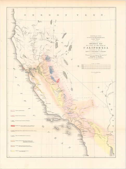
A majority of this map of California is colored to... (full text available to subscribers)
| Item Detail |
| |
| |
MapMaker: |
U.S. War Department
|
|
| |
| |
Subject: |
California |
|
| |
Period/Size: |
1856 / 22.1" x 16.2" (56.2 x 41.2 cm)
|
|
| |
Color: |
Colored
|
|
| |
Condition: |
(A) Issued folding with faint toning confined to the top blank margin. (condition help) |
|
| |
Source: |
Reports of Explorations and Surveys for a Railroad Route from the Mississippi Ri |
|
| |
References: |
Marcou & Marcou #678. |
|
| |
|
|
| Sales Information |
| |
| |
Price: |
|
|
| |
| |
Offered by: |
Old World Auctions |
|
| |
Catalog: |
Auction No. 162 - Antique Maps, Charts, Atlases & Globes (9354) |
|
| |
Lot/Item #: |
230 |
|
| |
| |
Date: |
04/2017
|
|
| |
| |
|
Antique Maps - Valuation and Pricing, Descriptions, Resources |
|
Home |
Information |
Search |
Register |
Contact Us |
Site Map
Americana Exchange, Inc. © 1999 - 2024 Americana Exchange, Inc.. All rights reserved.
OldMaps.com, the OldMaps.com logo and
AMPR are service marks or registered service marks of Americana Exchange, Inc..
|