Title:
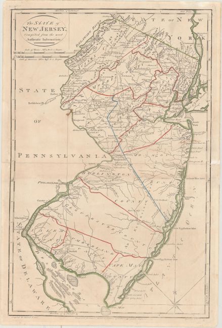
“The State of New Jersey, Compiled from the Most Authentic Information”
Map Maker:
Lewis/Carey
Handsome topographical map showing counties, the d... (full text available to subscribers)
| Item Detail |
| |
| |
MapMaker: |
Lewis/Carey
|
|
| |
| |
Subject: |
New Jersey |
|
| |
Period/Size: |
1795 / 18.5" x 12.2" (47.0 x 31.0 cm)
|
|
| |
Color: |
Colored
|
|
| |
Condition: |
(B+) Light soiling with a small stain near Bethlehem and an old manuscript notation south of Sandy Hook. The map has been professionally repaired along the centerfold where it was completely separated. Remnants of hinge tape on verso. (condition help) |
|
| |
Source: |
American Atlas |
|
| |
References: |
Wheat & Brun #414. |
|
| |
|
|
| Sales Information |
| |
| |
Price: |
|
|
| |
| |
Offered by: |
Old World Auctions |
|
| |
Catalog: |
Auction No. 162 - Antique Maps, Charts, Atlases & Globes (9354) |
|
| |
Lot/Item #: |
273 |
|
| |
| |
Date: |
04/2017
|
|
| |
| |
|
Antique Maps - Valuation and Pricing, Descriptions, Resources |
|
Home |
Information |
Search |
Register |
Contact Us |
Site Map
Americana Exchange, Inc. © 1999 - 2024 Americana Exchange, Inc.. All rights reserved.
OldMaps.com, the OldMaps.com logo and
AMPR are service marks or registered service marks of Americana Exchange, Inc..
|