Title:
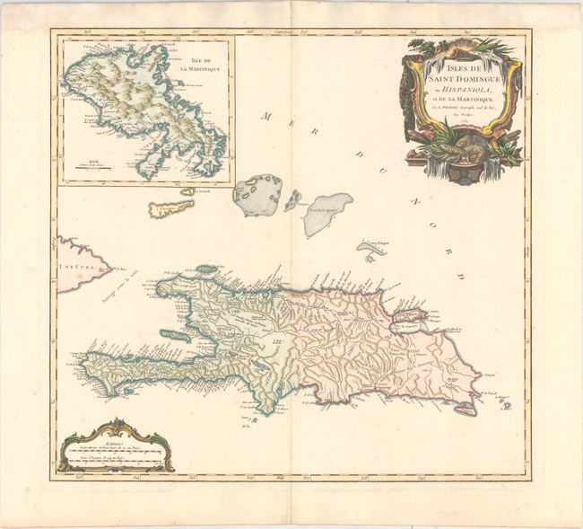
“Isles de Saint Domingue ou Hispaniola, et de la Martinique”
Map Maker:
Gilles Robert de Vaugondy
Superb large map of Hispaniola with a sizable inse... (full text available to subscribers)
| Item Detail |
| |
| |
MapMaker: |
Gilles Robert de Vaugondy
|
|
| |
| |
Subject: |
Hispaniola & Martinique |
|
| |
Period/Size: |
1750 / 18.9" x 20.3" (48.0 x 51.6 cm)
|
|
| |
Color: |
Colored
|
|
| |
Condition: |
(A) A crisp impression on watermarked paper with faint damp stains in top corners of sheet, outside of image. (condition help) |
|
| |
Source: |
Atlas Universel |
|
| |
References: |
Pedley #480. |
|
| |
|
|
| Sales Information |
| |
| |
Price: |
|
|
| |
| |
Offered by: |
Old World Auctions |
|
| |
Catalog: |
Auction No. 162 - Antique Maps, Charts, Atlases & Globes (9354) |
|
| |
Lot/Item #: |
377 |
|
| |
| |
Date: |
04/2017
|
|
| |
| |
|
Antique Maps - Valuation and Pricing, Descriptions, Resources |
|
Home |
Information |
Search |
Register |
Contact Us |
Site Map
Americana Exchange, Inc. © 1999 - 2024 Americana Exchange, Inc.. All rights reserved.
OldMaps.com, the OldMaps.com logo and
AMPR are service marks or registered service marks of Americana Exchange, Inc..
|