| Item Detail |
| |
| |
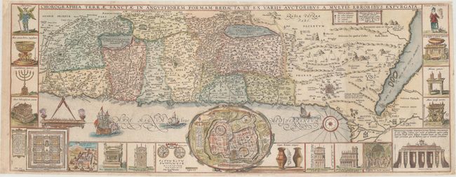
MapMaker: |
Jacobus Tirinus
|
|
| |
| |
Subject: |
Holy Land |
|
| |
Period/Size: |
1688 / 12.8" x 33.3" (32.6 x 84.6 cm)
|
|
| |
Color: |
Colored
|
|
| |
Condition: |
(B+) Issued folding, now flattened on watermarked paper with professional repairs to several short fold separations, a few small chips in the blank margins, and a hole in the bottom right corner that measures about 1/4" by 1/2", with a small amount of ima (condition help) |
|
| |
Source: |
|
|
| |
References: |
Laor #771. |
|
| |
|
|
| Sales Information |
| |
| |
Price: |
|
|
| |
| |
Offered by: |
Old World Auctions |
|
| |
Catalog: |
Auction No. 162 - Antique Maps, Charts, Atlases & Globes (9354) |
|
| |
Lot/Item #: |
630 |
|
| |
| |
Date: |
04/2017
|
|
| |
| |
|