Title:
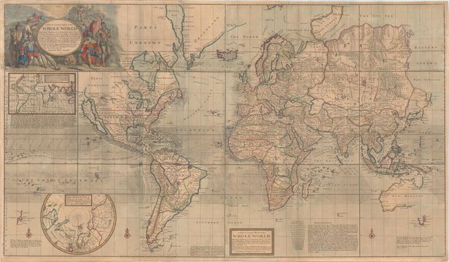
“A New & Correct Map of the Whole World Shewing ye Situation of Its Principal Parts. Viz the Oceans, Kingdoms, Rivers, Capes, Ports, Mountains, Woods, Trade-Winds, Monsoons, Variations of ye Compass, Climats, &c...”
Map Maker:
Herman Moll
This spectacular map on Mercator's projection is o... (full text available to subscribers)
| Item Detail |
| |
| |
MapMaker: |
Herman Moll
|
|
| |
| |
Subject: |
World |
|
| |
Period/Size: |
1719 / 27.7" x 47.8" (70.4 x 121.5 cm)
|
|
| |
Color: |
Colored
|
|
| |
Condition: |
(B) Issued folding and now flattened and backed with paper to reinforce and repair four edge tears at left and top ranging in size from 2" to 7" as well as a few minor fold separations. The sheet is lightly toned with scattered foxing and a faint damp st (condition help) |
|
| |
Source: |
|
|
| |
References: |
Shirley (BL Atlases) T.MOLL-4b-2; Wagner (NW) #512. |
|
| |
|
|
| Sales Information |
| |
| |
Price: |
|
|
| |
| |
Offered by: |
Old World Auctions |
|
| |
Catalog: |
Auction No. 163 - Antique Maps, Charts, Atlases & Globes (9365) |
|
| |
Lot/Item #: |
6 |
|
| |
| |
Date: |
06/2017
|
|
| |
| |
|
Antique Maps - Valuation and Pricing, Descriptions, Resources |
|
Home |
Information |
Search |
Register |
Contact Us |
Site Map
Americana Exchange, Inc. © 1999 - 2024 Americana Exchange, Inc.. All rights reserved.
OldMaps.com, the OldMaps.com logo and
AMPR are service marks or registered service marks of Americana Exchange, Inc..
|