Title:
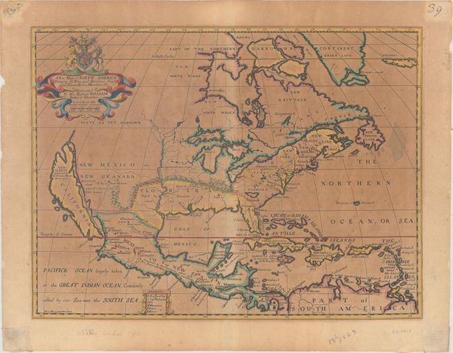
“A New Map of North America Shewing Its Principal Divisions, Chief Cities, Townes, Rivers, Mountains &c.”
Map Maker:
Edward Wells
This handsome map features the island of Califo... (full text available to subscribers)
| Item Detail |
| |
| |
MapMaker: |
Edward Wells
|
|
| |
| |
Subject: |
Colonial North America |
|
| |
Period/Size: |
1704 / 14.5" x 19.2" (36.9 x 48.8 cm)
|
|
| |
Color: |
Colored
|
|
| |
Condition: |
(C+) Moderate toning and foxing. There are remnants of stiff paper on verso at the sheet corners from a previous framing. (condition help) |
|
| |
Source: |
A New Sett of Maps Both of Ancient and Present Geography... |
|
| |
References: |
Burden #758; McLaughlin #142; Tooley (Amer) p. 128, #69, plt. #53. |
|
| |
|
|
| Sales Information |
| |
| |
Price: |
|
|
| |
| |
Offered by: |
Old World Auctions |
|
| |
Catalog: |
Auction No. 163 - Antique Maps, Charts, Atlases & Globes (9365) |
|
| |
Lot/Item #: |
28 |
|
| |
| |
Date: |
06/2017
|
|
| |
| |
|
Antique Maps - Valuation and Pricing, Descriptions, Resources |
|
Home |
Information |
Search |
Register |
Contact Us |
Site Map
Americana Exchange, Inc. © 1999 - 2024 Americana Exchange, Inc.. All rights reserved.
OldMaps.com, the OldMaps.com logo and
AMPR are service marks or registered service marks of Americana Exchange, Inc..
|