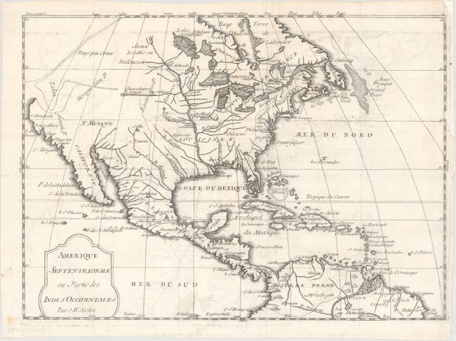
Title:
“Amerique Septentrionale ou Partie des Indes Occidentales”
Map Maker:
Jean Batiste Nolin
This scarce map was published in a French account ... (full text available to subscribers)
| Item Detail |
| |
| |
MapMaker: |
Jean Batiste Nolin
|
|
| |
| |
Subject: |
Colonial North America |
|
| |
Period/Size: |
1722 / 8.4" x 11.6" (21.4 x 29.5 cm)
|
|
| |
Color: |
Black & White
|
|
| |
Condition: |
(B+) Issued folding on watermarked paper with light offsetting and an extraneous crease at bottom left. Several short fold separations in the map and a chip at right just entering the border have been professionally repaired on verso with old paper. (condition help) |
|
| |
Source: |
Voyages de Francois Coreal au Indes Occidentales |
|
| |
References: |
Sabin #16781. |
|
| |
|
|
| Sales Information |
| |
| |
Price: |
|
|
| |
| |
Offered by: |
Old World Auctions |
|
| |
Catalog: |
Auction No. 163 - Antique Maps, Charts, Atlases & Globes (9365) |
|
| |
Lot/Item #: |
31 |
|
| |
| |
Date: |
06/2017
|
|
| |
| |
|
Antique Maps - Valuation and Pricing, Descriptions, Resources |
|
Home |
Information |
Search |
Register |
Contact Us |
Site Map
Americana Exchange, Inc. © 1999 - 2024 Americana Exchange, Inc.. All rights reserved.
OldMaps.com, the OldMaps.com logo and
AMPR are service marks or registered service marks of Americana Exchange, Inc..
|