Title:
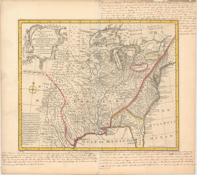
“A New & Accurate Map of Louisiana, with Part of Florida and Canada, and the Adjacent Countries. Drawn from Surveys, Assisted by the Most Approved English & French Maps & Charts...”
Map Maker:
Emanuel Bowen
A beautifully detailed map extends west to the Rio... (full text available to subscribers)
| Item Detail |
| |
| |
MapMaker: |
Emanuel Bowen
|
|
| |
| |
Subject: |
Colonial Eastern United States |
|
| |
Period/Size: |
1747 / 13.6" x 16.6" (34.6 x 42.2 cm)
|
|
| |
Color: |
Colored
|
|
| |
Condition: |
(A) A dark impression on a sheet of watermarked paper. There are extensive old manuscript notations in the blank margins that describe the region and make the map more interesting. (condition help) |
|
| |
Source: |
A Complete System of Geography |
|
| |
References: |
McCorkle (18th C. Geog. Books) #17-28 (Vol II); Phillips (A) #603-2-58; Lemmon, Magill & Wiese (Char |
|
| |
|
|
| Sales Information |
| |
| |
Price: |
|
|
| |
| |
Offered by: |
Old World Auctions |
|
| |
Catalog: |
Auction No. 163 - Antique Maps, Charts, Atlases & Globes (9365) |
|
| |
Lot/Item #: |
100 |
|
| |
| |
Date: |
06/2017
|
|
| |
| |
|
Antique Maps - Valuation and Pricing, Descriptions, Resources |
|
Home |
Information |
Search |
Register |
Contact Us |
Site Map
Americana Exchange, Inc. © 1999 - 2024 Americana Exchange, Inc.. All rights reserved.
OldMaps.com, the OldMaps.com logo and
AMPR are service marks or registered service marks of Americana Exchange, Inc..
|