Title:
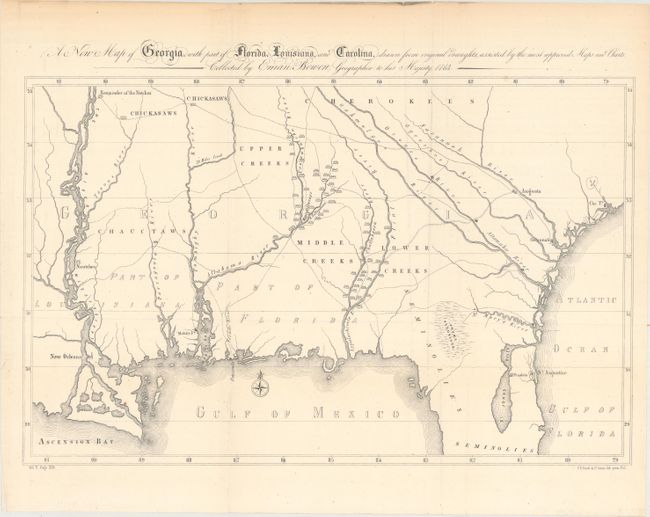
“A New Map of Georgia, with Part of Florida, Louisiana, and Carolina, Drawn from Original Draughts, Assisted by the Most Approved Maps and Charts. Collected by Eman: Bowen...”
Map Maker:
Henry Rowe Schoolcraft
Schoolcraft used a simplified version of Emanuel B... (full text available to subscribers)
| Item Detail |
| |
| |
MapMaker: |
Henry Rowe Schoolcraft
|
|
| |
| |
Subject: |
Southern United States, Georgia |
|
| |
Period/Size: |
1855 / 11.8" x 18.5" (30.0 x 47.0 cm)
|
|
| |
Color: |
Black & White
|
|
| |
Condition: |
(A) Issued folding with a few minor mis-folds, one tiny hole in the image, and light toning along the top edge of the sheet, not affecting map. (condition help) |
|
| |
Source: |
History of the Indian Tribes Vol. 5 |
|
| |
References: |
|
|
| |
|
|
| Sales Information |
| |
| |
Price: |
|
|
| |
| |
Offered by: |
Old World Auctions |
|
| |
Catalog: |
Auction No. 163 - Antique Maps, Charts, Atlases & Globes (9365) |
|
| |
Lot/Item #: |
175 |
|
| |
| |
Date: |
06/2017
|
|
| |
| |
|
Antique Maps - Valuation and Pricing, Descriptions, Resources |
|
Home |
Information |
Search |
Register |
Contact Us |
Site Map
Americana Exchange, Inc. © 1999 - 2024 Americana Exchange, Inc.. All rights reserved.
OldMaps.com, the OldMaps.com logo and
AMPR are service marks or registered service marks of Americana Exchange, Inc..
|