Title:
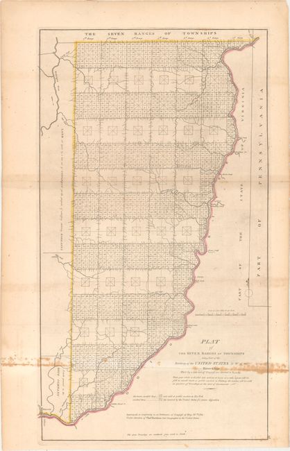
“Plat of the Seven Ranges of Townships Being Part of the Territory of the United States N.W. of the River Ohio...”
Map Maker:
Thomas Hutchins
An important early map of eastern Ohio completed u... (full text available to subscribers)
| Item Detail |
| |
| |
MapMaker: |
Thomas Hutchins
|
|
| |
| |
Subject: |
Eastern Ohio |
|
| |
Period/Size: |
1814 / 24.3" x 13.9" (61.8 x 35.3 cm)
|
|
| |
Color: |
Colored
|
|
| |
Condition: |
(B) Issued folding with light toning and scattered foxing along the lower fold. There is a short fold separation confined to the right blank margin and an edge tear at top that has been closed on verso with archival tape. (condition help) |
|
| |
Source: |
Carey's General Atlas |
|
| |
References: |
Phillips (Atlases) #722-28; cf. Wheat & Brun #677. |
|
| |
|
|
| Sales Information |
| |
| |
Price: |
|
|
| |
| |
Offered by: |
Old World Auctions |
|
| |
Catalog: |
Auction No. 163 - Antique Maps, Charts, Atlases & Globes (9365) |
|
| |
Lot/Item #: |
336 |
|
| |
| |
Date: |
06/2017
|
|
| |
| |
|
Antique Maps - Valuation and Pricing, Descriptions, Resources |
|
Home |
Information |
Search |
Register |
Contact Us |
Site Map
Americana Exchange, Inc. © 1999 - 2024 Americana Exchange, Inc.. All rights reserved.
OldMaps.com, the OldMaps.com logo and
AMPR are service marks or registered service marks of Americana Exchange, Inc..
|