Rister or Sign In to see pricing information


Title:

Map of the River Sabine from Its Mouth on the Gulf of Mexico in the Sea to Logan's Ferry...

Map Maker:

U.S. Government

Map of the River Sabine from Its Mouth on the Gulf of Mexico in the Sea to Logan's Ferry...

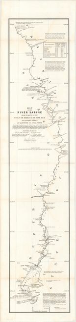
This is one of six maps issued with the report on ... (full text available to subscribers)
Item Detail
 
  MapMaker:  

U.S. Government


  Subject:  Texas-Louisiana Border  
  Period/Size:  1842 / 34.3" x 7.2"  (87.2 x 18.3 cm)  
  Color:  Black & White  
  Condition:  (B+) Issued folding with occasional faint staining. (condition help)  
  Source:  Sen. Doc. 199, 27th Cong., 2nd Sess.  
  References:  Claussen & Friis #417; Day #952; Martin & Martin p. 36.  
 
 
Sales Information
 
  Price: 

Please register your email to view records, or sign in with email address to see records


  Offered by:  Old World Auctions  
  Catalog:  Auction No. 163 - Antique Maps, Charts, Atlases & Globes (9365)  
  Lot/Item #:  368  
 
  Date:  06/2017  


Antique Maps - Valuation and Pricing, Descriptions, Resources


Home | Information | Search | Register | Contact Us | Site Map

Americana Exchange, Inc. © 1999 - 2024 Americana Exchange, Inc.. All rights reserved. OldMaps.com, the OldMaps.com logo and
AMPR are service marks or registered service marks of Americana Exchange, Inc..