Title:
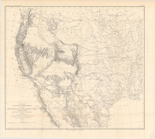
“Map of the United States and Their Territories Between the Mississippi and the Pacific Ocean and Part of Mexico Compiled from Surveys Made Under the Order of W.H. Emory...”
Map Maker:
William Hemsley Emory
This map is one of the foundation maps for the ... (full text available to subscribers)
| Item Detail |
| |
| |
MapMaker: |
William Hemsley Emory
|
|
| |
| |
Subject: |
Western United States & Mexico |
|
| |
Period/Size: |
1857-58 / 20.3" x 23.0" (51.6 x 58.5 cm)
|
|
| |
Color: |
Black & White
|
|
| |
Condition: |
(B+) This example is quite clean and bright save for some very light offsetting at bottom and light toning along the top edge of the sheet. There is one mis-fold in the title. (condition help) |
|
| |
Source: |
United States & Mexican Boundary Survey |
|
| |
References: |
Wheat (TMW) #916. |
|
| |
|
|
| Sales Information |
| |
| |
Price: |
|
|
| |
| |
Offered by: |
Old World Auctions |
|
| |
Catalog: |
Auction No. 163 - Antique Maps, Charts, Atlases & Globes (9365) |
|
| |
Lot/Item #: |
404 |
|
| |
| |
Date: |
06/2017
|
|
| |
| |
|
Antique Maps - Valuation and Pricing, Descriptions, Resources |
|
Home |
Information |
Search |
Register |
Contact Us |
Site Map
Americana Exchange, Inc. © 1999 - 2024 Americana Exchange, Inc.. All rights reserved.
OldMaps.com, the OldMaps.com logo and
AMPR are service marks or registered service marks of Americana Exchange, Inc..
|