Title:
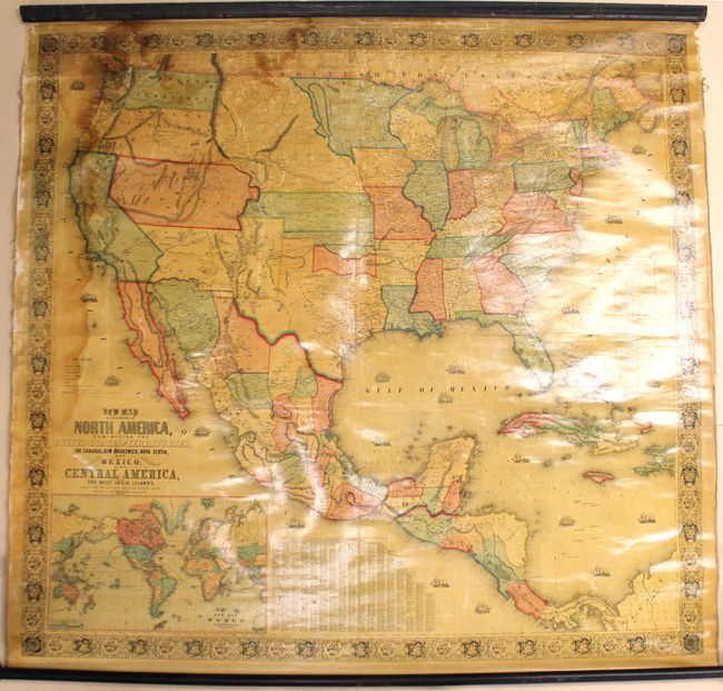
“New Map of That Portion of North America, Exhibiting the United States and Territories, the Canadas, New Brunswick, Nova Scotia, and Mexico, Also, Central America, and the West India Islands...”
Map Maker:
Jacob Monk
This majestic wall map was published just as the c... (full text available to subscribers)
| Item Detail |
| |
| |
MapMaker: |
Jacob Monk
|
|
| |
| |
Subject: |
North America |
|
| |
Period/Size: |
1854 / 55.6" x 59.1" (141.3 x 150.2 cm)
|
|
| |
Color: |
Colored
|
|
| |
Condition: |
(B+) The map is overall bright, mostly clean, and in very good condition. There is a damp stain along the left border and at top left. There are the commonly seen small cracks concentrated in the top third of the image and some minor chips in the left a (condition help) |
|
| |
Source: |
|
|
| |
References: |
cf. Wheat (TMW) #794; cf. Wheat (GOLD) 243. |
|
| |
|
|
| Sales Information |
| |
| |
Price: |
|
|
| |
| |
Offered by: |
Old World Auctions |
|
| |
Catalog: |
Auction No. 164 - Antique Maps, Charts, Atlases & Globes (9364) |
|
| |
Lot/Item #: |
87 |
|
| |
| |
Date: |
09/2017
|
|
| |
| |
|
Antique Maps - Valuation and Pricing, Descriptions, Resources |
|
Home |
Information |
Search |
Register |
Contact Us |
Site Map
Americana Exchange, Inc. © 1999 - 2024 Americana Exchange, Inc.. All rights reserved.
OldMaps.com, the OldMaps.com logo and
AMPR are service marks or registered service marks of Americana Exchange, Inc..
|