Title:
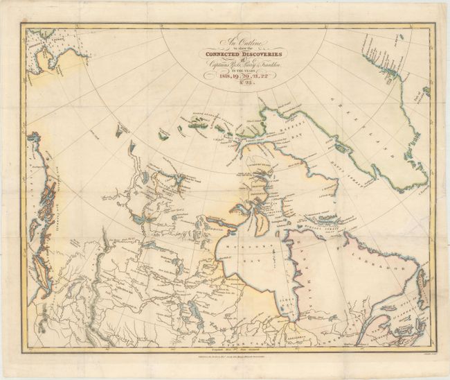
“An Outline to Shew the Connected Discoveries of Captains Ross, Parry & Franklin, in the Years 1818, 19, 20, 21, 22 & 23”
Map Maker:
John Franklin
This map charts the discoveries in the Arctic made... (full text available to subscribers)
| Item Detail |
| |
| |
MapMaker: |
John Franklin
|
|
| |
| |
Subject: |
Canada |
|
| |
Period/Size: |
1823 / 14.4" x 18.1" (36.6 x 46.0 cm)
|
|
| |
Color: |
Colored
|
|
| |
Condition: |
(B+) Issued folding, now flattened with very light soiling, minor creasing, a couple of tiny fold separations, and a 2" tear at right that has been archivally repaired. (condition help) |
|
| |
Source: |
Narrative of a Journey to the Shores of the Polar Sea |
|
| |
References: |
Sabin #25625. |
|
| |
|
|
| Sales Information |
| |
| |
Price: |
|
|
| |
| |
Offered by: |
Old World Auctions |
|
| |
Catalog: |
Auction No. 164 - Antique Maps, Charts, Atlases & Globes (9364) |
|
| |
Lot/Item #: |
96 |
|
| |
| |
Date: |
09/2017
|
|
| |
| |
|
Antique Maps - Valuation and Pricing, Descriptions, Resources |
|
Home |
Information |
Search |
Register |
Contact Us |
Site Map
Americana Exchange, Inc. © 1999 - 2024 Americana Exchange, Inc.. All rights reserved.
OldMaps.com, the OldMaps.com logo and
AMPR are service marks or registered service marks of Americana Exchange, Inc..
|