Rister or Sign In to see pricing information


Title:

Carte des Decouvertes du Capitaine Parry en 1819 et 1820

Map Maker:

William Edward Parry

Carte des Decouvertes du Capitaine Parry en 1819 et 1820

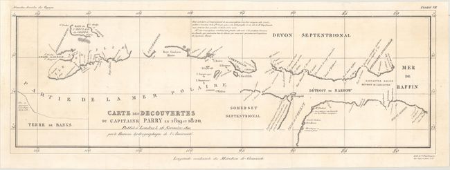
This map charts the discoveries in the Arctic made... (full text available to subscribers)
Item Detail
 
  MapMaker:  

William Edward Parry


  Subject:  Canadian Arctic  
  Period/Size:  1820 / 8.5" x 25.0"  (21.6 x 63.5 cm)  
  Color:  Black & White  
  Condition:  (A) Issued folding, now flattened, with a hint of soiling. A chip in the left blank margin has been professionally repaired. (condition help)  
  Source:  Nouvelles Annales des Voyages  
  References:   
 
 
Sales Information
 
  Price: 

Please register your email to view records, or sign in with email address to see records


  Offered by:  Old World Auctions  
  Catalog:  Auction No. 164 - Antique Maps, Charts, Atlases & Globes (9364)  
  Lot/Item #:  98  
 
  Date:  09/2017  


Antique Maps - Valuation and Pricing, Descriptions, Resources


Home | Information | Search | Register | Contact Us | Site Map

Americana Exchange, Inc. © 1999 - 2024 Americana Exchange, Inc.. All rights reserved. OldMaps.com, the OldMaps.com logo and
AMPR are service marks or registered service marks of Americana Exchange, Inc..