Title:
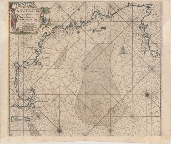
“Pas-Kaart vande Zee Kusten inde Boght van Niew Engeland Tusschen de Staaten Hoek en C. de Sable”
Map Maker:
Johannes van Keulen
This is one of the earliest obtainable sea charts ... (full text available to subscribers)
| Item Detail |
| |
| |
MapMaker: |
Johannes van Keulen
|
|
| |
| |
Subject: |
Colonial New England United States |
|
| |
Period/Size: |
1702 / 20.3" x 23.3" (51.6 x 59.2 cm)
|
|
| |
Color: |
Colored
|
|
| |
Condition: |
(A) A dark impression with light printer's ink residue and several minor professional repairs in the blank margins. (condition help) |
|
| |
Source: |
De Niewe Groot Lichtende Zee-Fakkel |
|
| |
References: |
Burden #586; McCorkle #684.2. |
|
| |
|
|
| Sales Information |
| |
| |
Price: |
|
|
| |
| |
Offered by: |
Old World Auctions |
|
| |
Catalog: |
Auction No. 164 - Antique Maps, Charts, Atlases & Globes (9364) |
|
| |
Lot/Item #: |
163 |
|
| |
| |
Date: |
09/2017
|
|
| |
| |
|
Antique Maps - Valuation and Pricing, Descriptions, Resources |
|
Home |
Information |
Search |
Register |
Contact Us |
Site Map
Americana Exchange, Inc. © 1999 - 2024 Americana Exchange, Inc.. All rights reserved.
OldMaps.com, the OldMaps.com logo and
AMPR are service marks or registered service marks of Americana Exchange, Inc..
|