Title:
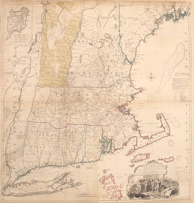
“A Map of the Most Inhabited Part of New England, Containing the Provinces of Massachusets Bay and New Hampshire, with the Colonies of Conecticut and Rhode Island...”
Map Maker:
Thomas Jefferys
This is the fifth state of Jefferys' celebrated la... (full text available to subscribers)
| Item Detail |
| |
| |
MapMaker: |
Thomas Jefferys
|
|
| |
| |
Subject: |
Colonial New England United States |
|
| |
Period/Size: |
1774 / 40.9" x 39.2" (103.9 x 99.6 cm)
|
|
| |
Color: |
Colored
|
|
| |
Condition: |
(B+) Light soiling and offsetting with some toning along the joints. There are short splits along the centerfolds of the sheets at top and bottom that have been archivally repaired. (condition help) |
|
| |
Source: |
|
|
| |
References: |
Tooley (Amer) p.71; McCorkle 755.19; Pritchard & Taliaferro #35; Stevens & Tree #33(e). |
|
| |
|
|
| Sales Information |
| |
| |
Price: |
|
|
| |
| |
Offered by: |
Old World Auctions |
|
| |
Catalog: |
Auction No. 164 - Antique Maps, Charts, Atlases & Globes (9364) |
|
| |
Lot/Item #: |
164 |
|
| |
| |
Date: |
09/2017
|
|
| |
| |
|
Antique Maps - Valuation and Pricing, Descriptions, Resources |
|
Home |
Information |
Search |
Register |
Contact Us |
Site Map
Americana Exchange, Inc. © 1999 - 2024 Americana Exchange, Inc.. All rights reserved.
OldMaps.com, the OldMaps.com logo and
AMPR are service marks or registered service marks of Americana Exchange, Inc..
|