Title:
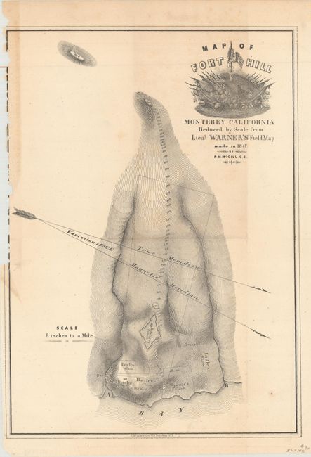
“Map of Fort Hill Monterey California Reduced by Scale from Lieut Warner's Field Map Made in 1847 by P.M. McGill, C.E.”
Map Maker:
U.S. War Department
A fully engraved map with much topographical infor... (full text available to subscribers)
| Item Detail |
| |
| |
MapMaker: |
U.S. War Department
|
|
| |
| |
Subject: |
Northern California |
|
| |
Period/Size: |
1850 / 13.0" x 9.2" (33.1 x 23.4 cm)
|
|
| |
Color: |
Black & White
|
|
| |
Condition: |
(B) Issued folding with a binding trim at top left that just enters the neatline. There is faint scattered foxing and an extraneous crease at bottom left. (condition help) |
|
| |
Source: |
HR Doc. 17, 31st Congress, 1st Session |
|
| |
References: |
|
|
| |
|
|
| Sales Information |
| |
| |
Price: |
|
|
| |
| |
Offered by: |
Old World Auctions |
|
| |
Catalog: |
Auction No. 164 - Antique Maps, Charts, Atlases & Globes (9364) |
|
| |
Lot/Item #: |
232 |
|
| |
| |
Date: |
09/2017
|
|
| |
| |
|
Antique Maps - Valuation and Pricing, Descriptions, Resources |
|
Home |
Information |
Search |
Register |
Contact Us |
Site Map
Americana Exchange, Inc. © 1999 - 2024 Americana Exchange, Inc.. All rights reserved.
OldMaps.com, the OldMaps.com logo and
AMPR are service marks or registered service marks of Americana Exchange, Inc..
|