Title:
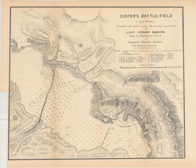
“Custer's Battle-Field (June 25th 1876) Surveyed and Drawn Under the Personal Supervision of Lieut. Edward Maguire Corps of Engineers U.S.A.”
Map Maker:
Edward Maguire
An excellent terrain map of the scene of Custer's ... (full text available to subscribers)
| Item Detail |
| |
| |
MapMaker: |
Edward Maguire
|
|
| |
| |
Subject: |
Montana |
|
| |
Period/Size: |
1876 / 15.0" x 17.5" (38.1 x 44.5 cm)
|
|
| |
Color: |
Black & White
|
|
| |
Condition: |
(B+) Issued folding with pleasant light toning. (condition help) |
|
| |
Source: |
Annual Report of Lieutenant Edward Maguire, Corps of Engineers… |
|
| |
References: |
Wheat (TMW) #1266. |
|
| |
|
|
| Sales Information |
| |
| |
Price: |
|
|
| |
| |
Offered by: |
Old World Auctions |
|
| |
Catalog: |
Auction No. 164 - Antique Maps, Charts, Atlases & Globes (9364) |
|
| |
Lot/Item #: |
302 |
|
| |
| |
Date: |
09/2017
|
|
| |
| |
|
Antique Maps - Valuation and Pricing, Descriptions, Resources |
|
Home |
Information |
Search |
Register |
Contact Us |
Site Map
Americana Exchange, Inc. © 1999 - 2024 Americana Exchange, Inc.. All rights reserved.
OldMaps.com, the OldMaps.com logo and
AMPR are service marks or registered service marks of Americana Exchange, Inc..
|