Title:
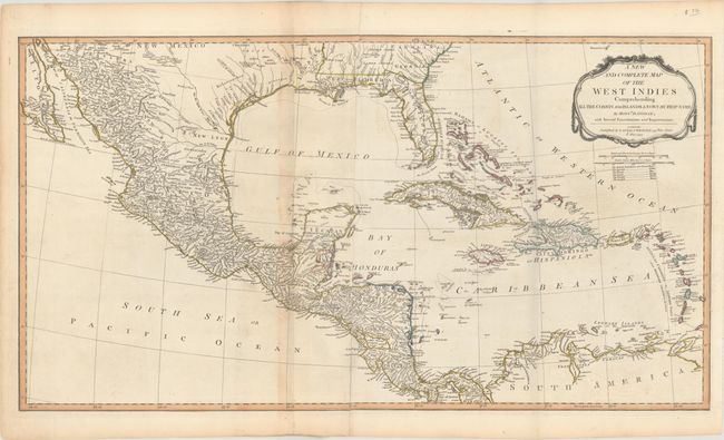
“A New and Complete Map of the West Indies Comprehending All the Coasts and Islands Known by That Name by Monsr. D Anville; with Several Emendations and Improvements”
Map Maker:
Laurie & Whittle
This large map of the Gulf of Mexico and Caribbean... (full text available to subscribers)
| Item Detail |
| |
| |
MapMaker: |
Laurie & Whittle
|
|
| |
| |
Subject: |
Gulf of Mexico & Caribbean |
|
| |
Period/Size: |
1794 / 18.4" x 33.9" (46.8 x 86.1 cm)
|
|
| |
Color: |
Colored
|
|
| |
Condition: |
(B+) Issued folding on watermarked paper with light toning along the sheet joint and minor offsetting of the title. (condition help) |
|
| |
Source: |
A New and Elegant Imperial Sheet Atlas |
|
| |
References: |
Phillips (Atlases) #720-52. |
|
| |
|
|
| Sales Information |
| |
| |
Price: |
|
|
| |
| |
Offered by: |
Old World Auctions |
|
| |
Catalog: |
Auction No. 164 - Antique Maps, Charts, Atlases & Globes (9364) |
|
| |
Lot/Item #: |
382 |
|
| |
| |
Date: |
09/2017
|
|
| |
| |
|
Antique Maps - Valuation and Pricing, Descriptions, Resources |
|
Home |
Information |
Search |
Register |
Contact Us |
Site Map
Americana Exchange, Inc. © 1999 - 2024 Americana Exchange, Inc.. All rights reserved.
OldMaps.com, the OldMaps.com logo and
AMPR are service marks or registered service marks of Americana Exchange, Inc..
|