Title:
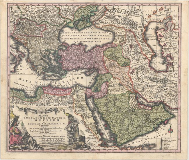
“Magni Turcarum Dominatoris Imperium per Europam, Asiam, et Africam, se Extendens Regiones tam Proprias, quam Tributarias et Clientelares...”
Map Maker:
Matthaus Seutter
This striking map covers the Turkish Empire, exten... (full text available to subscribers)
| Item Detail |
| |
| |
MapMaker: |
Matthaus Seutter
|
|
| |
| |
Subject: |
Eastern Mediterranean & Middle East |
|
| |
Period/Size: |
1740 / 19.6" x 22.8" (49.8 x 58.0 cm)
|
|
| |
Color: |
Colored
|
|
| |
Condition: |
(A) A dark impression on watermarked paper with bold, original color in the map and later color in the cartouche. There is minor soiling primarily confined to the blank margins, and archival repairs to a short centerfold separation at top and a tear conf (condition help) |
|
| |
Source: |
|
|
| |
References: |
Ankary #153. |
|
| |
|
|
| Sales Information |
| |
| |
Price: |
|
|
| |
| |
Offered by: |
Old World Auctions |
|
| |
Catalog: |
Auction No. 164 - Antique Maps, Charts, Atlases & Globes (9364) |
|
| |
Lot/Item #: |
635 |
|
| |
| |
Date: |
09/2017
|
|
| |
| |
|
Antique Maps - Valuation and Pricing, Descriptions, Resources |
|
Home |
Information |
Search |
Register |
Contact Us |
Site Map
Americana Exchange, Inc. © 1999 - 2024 Americana Exchange, Inc.. All rights reserved.
OldMaps.com, the OldMaps.com logo and
AMPR are service marks or registered service marks of Americana Exchange, Inc..
|