Title:
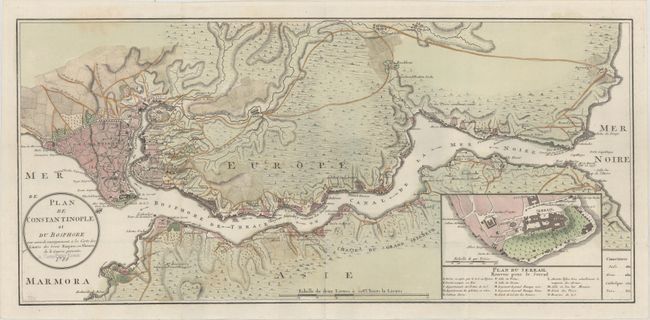
“Plan de Constantinople et du Bosphore pour Servir de Renseignement a la Carte des Limites des Trois Empires, ou Theatre de la Guerre Presente”
Map Maker:
Francois Joseph Maire
This map depicts the Bosphorus Strait between the ... (full text available to subscribers)
| Item Detail |
| |
| |
MapMaker: |
Francois Joseph Maire
|
|
| |
| |
Subject: |
Bosphorus, Turkey |
|
| |
Period/Size: |
1788 / 10.8" x 23.3" (27.5 x 59.2 cm)
|
|
| |
Color: |
Colored
|
|
| |
Condition: |
(A) A clean and bright example, issued folding on sturdy paper with a small hole at a fold intersection and a previous owner's stamp (D. Hans-Peter Kosac) just below the title. (condition help) |
|
| |
Source: |
|
|
| |
References: |
|
|
| |
|
|
| Sales Information |
| |
| |
Price: |
|
|
| |
| |
Offered by: |
Old World Auctions |
|
| |
Catalog: |
Auction No. 164 - Antique Maps, Charts, Atlases & Globes (9364) |
|
| |
Lot/Item #: |
644 |
|
| |
| |
Date: |
09/2017
|
|
| |
| |
|
Antique Maps - Valuation and Pricing, Descriptions, Resources |
|
Home |
Information |
Search |
Register |
Contact Us |
Site Map
Americana Exchange, Inc. © 1999 - 2024 Americana Exchange, Inc.. All rights reserved.
OldMaps.com, the OldMaps.com logo and
AMPR are service marks or registered service marks of Americana Exchange, Inc..
|