Title:
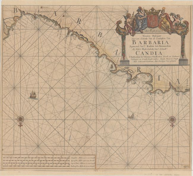
“Nieuwe Pascaart voor een Gedeelte van de Zeekusten van Barbaria Beginnende van C: Rusato tot Alexandria als Mede t' Meeste Gedeelte van t' Eylandt Candia”
Map Maker:
Johannes van Keulen
Interesting sea chart of portions of the Libyan an... (full text available to subscribers)
| Item Detail |
| |
| |
MapMaker: |
Johannes van Keulen
|
|
| |
| |
Subject: |
Northern Africa |
|
| |
Period/Size: |
1682 / 20.1" x 22.7" (51.1 x 57.7 cm)
|
|
| |
Color: |
Colored
|
|
| |
Condition: |
(B) There are several short centerfold separations that have been archivally repaired on verso along with a few faint spots. The sheet has been trimmed to just inside the neatline at top and bottom, and new margins have been added with old paper to bette (condition help) |
|
| |
Source: |
|
|
| |
References: |
Phillips (Atlases) #3444-17 (Volume 2). |
|
| |
|
|
| Sales Information |
| |
| |
Price: |
|
|
| |
| |
Offered by: |
Old World Auctions |
|
| |
Catalog: |
Auction No. 164 - Antique Maps, Charts, Atlases & Globes (9364) |
|
| |
Lot/Item #: |
703 |
|
| |
| |
Date: |
09/2017
|
|
| |
| |
|
Antique Maps - Valuation and Pricing, Descriptions, Resources |
|
Home |
Information |
Search |
Register |
Contact Us |
Site Map
Americana Exchange, Inc. © 1999 - 2024 Americana Exchange, Inc.. All rights reserved.
OldMaps.com, the OldMaps.com logo and
AMPR are service marks or registered service marks of Americana Exchange, Inc..
|