Title:
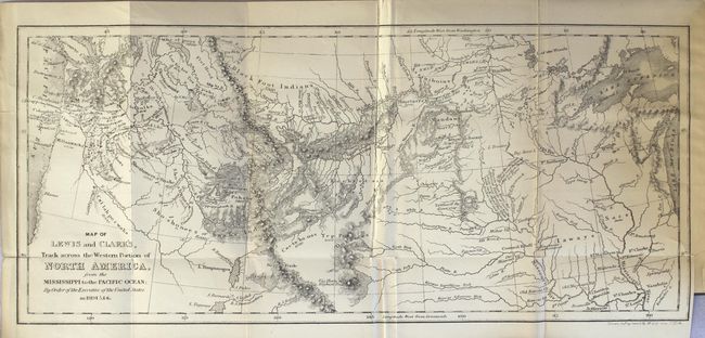
“History of the Expedition Under the Command of Captains Lewis and Clarke, to the Sources of the Missouri, Thence Across the Rocky Mountains…”
Map Maker:
Lewis & Clark
This is a later edition of Harper and Brothers' ab... (full text available to subscribers)
| Item Detail |
| |
| |
MapMaker: |
Lewis & Clark
|
|
| |
| |
Subject: |
Exploration, western U.S. |
|
| |
Period/Size: |
1842 / 6.3" x 4.0" (16.0 x 10.2 cm)
|
|
| |
Color: |
Black & White
|
|
| |
Condition: |
(B) The map is lightly toned with numerous fold separations that have been repaired on verso with archival tape. Text is lightly toned with one small pencil notation in the introduction (page 23). A postcard from the Lewis & Clark Exposition is pasted o (condition help) |
|
| |
Source: |
|
|
| |
References: |
Howes #L317; Sabin #40833. |
|
| |
|
|
| Sales Information |
| |
| |
Price: |
|
|
| |
| |
Offered by: |
Old World Auctions |
|
| |
Catalog: |
Auction No. 164 - Antique Maps, Charts, Atlases & Globes (9364) |
|
| |
Lot/Item #: |
778 |
|
| |
| |
Date: |
09/2017
|
|
| |
| |
|
Antique Maps - Valuation and Pricing, Descriptions, Resources |
|
Home |
Information |
Search |
Register |
Contact Us |
Site Map
Americana Exchange, Inc. © 1999 - 2024 Americana Exchange, Inc.. All rights reserved.
OldMaps.com, the OldMaps.com logo and
AMPR are service marks or registered service marks of Americana Exchange, Inc..
|