Title:
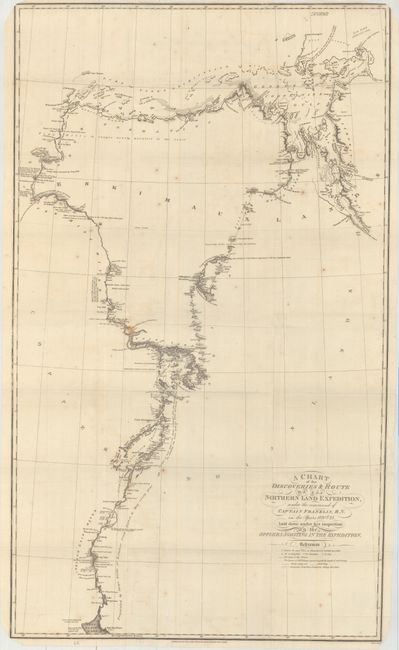
“A Chart of the Discoveries & Route of the Northern Land Expedition, Under the Command of Captain Franklin, R.N. in the Years 1820 & 21...”
Map Maker:
John Franklin
This detailed chart depicts Franklin's outgoing ro... (full text available to subscribers)
| Item Detail |
| |
| |
MapMaker: |
John Franklin
|
|
| |
| |
Subject: |
Northern Canada |
|
| |
Period/Size: |
1823 / 31.8" x 18.9" (80.8 x 48.0 cm)
|
|
| |
Color: |
Black & White
|
|
| |
Condition: |
(B+) Issued folding with light scattered foxing and faint offsetting. (condition help) |
|
| |
Source: |
Narrative of a Journey to the Shores of the Polar Sea |
|
| |
References: |
Sabin #25625. |
|
| |
|
|
| Sales Information |
| |
| |
Price: |
|
|
| |
| |
Offered by: |
Old World Auctions |
|
| |
Catalog: |
Auction No. 165 - Antique Maps, Charts, Atlases & Globes (9380) |
|
| |
Lot/Item #: |
80 |
|
| |
| |
Date: |
11/2017
|
|
| |
| |
|
Antique Maps - Valuation and Pricing, Descriptions, Resources |
|
Home |
Information |
Search |
Register |
Contact Us |
Site Map
Americana Exchange, Inc. © 1999 - 2024 Americana Exchange, Inc.. All rights reserved.
OldMaps.com, the OldMaps.com logo and
AMPR are service marks or registered service marks of Americana Exchange, Inc..
|