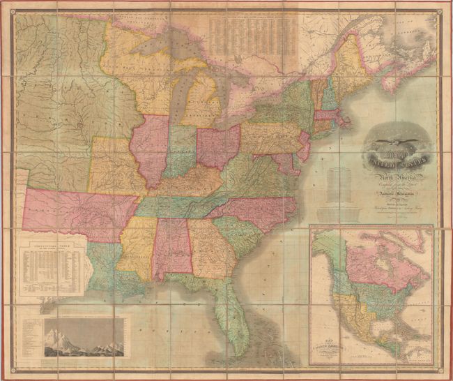
Title:
“Map of the United States of North America Compiled from the Latest and Most Authentic Information”
Map Maker:
David H. Vance
This scarce, first edition map depicts the eastern... (full text available to subscribers)
| Item Detail |
| |
| |
MapMaker: |
David H. Vance
|
|
| |
| |
Subject: |
Eastern United States |
|
| |
Period/Size: |
1825 / 51.8" x 61.6" (131.6 x 156.5 cm)
|
|
| |
Color: |
Colored
|
|
| |
Condition: |
(B) Overall good condition with light to moderate toning and foxing. Dissected panels have no chips or tears in the image and are firmly attached to the original linen, which has separated only along one panel at top. Ribbon edging is fully present and (condition help) |
|
| |
Source: |
|
|
| |
References: |
Rumsey #3961; Phillips (Maps) p. 883; Streeter Sale #3820; Inset Map - Wheat #368 (TMW). |
|
| |
|
|
| Sales Information |
| |
| |
Price: |
|
|
| |
| |
Offered by: |
Old World Auctions |
|
| |
Catalog: |
Auction No. 165 - Antique Maps, Charts, Atlases & Globes (9380) |
|
| |
Lot/Item #: |
122 |
|
| |
| |
Date: |
11/2017
|
|
| |
| |
|
Antique Maps - Valuation and Pricing, Descriptions, Resources |
|
Home |
Information |
Search |
Register |
Contact Us |
Site Map
Americana Exchange, Inc. © 1999 - 2024 Americana Exchange, Inc.. All rights reserved.
OldMaps.com, the OldMaps.com logo and
AMPR are service marks or registered service marks of Americana Exchange, Inc..
|