Title:
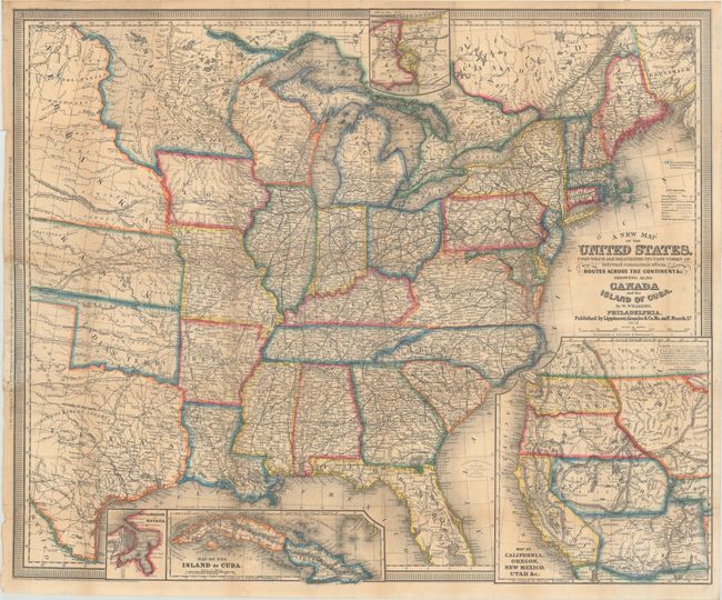
“A New Map of the United States. Upon Which Are Delineated Its Vast Works of Internal Communication, with the Proposed Routes Across the Continents &c...”
Map Maker:
Wellington Williams
This is the third edition of this highly detailed,... (full text available to subscribers)
| Item Detail |
| |
| |
MapMaker: |
Wellington Williams
|
|
| |
| |
Subject: |
Eastern United States |
|
| |
Period/Size: |
1857 / 24.3" x 29.4" (61.8 x 74.7 cm)
|
|
| |
Color: |
Colored
|
|
| |
Condition: |
(B+) Issued folding and now flattened and backed with tissue to reinforce and repair several tiny fold separations, with minute loss of image at a few fold separations. Additional repairs have been made to a few small chips and edge tears in left border (condition help) |
|
| |
Source: |
|
|
| |
References: |
Wheat (TMW) #927; cf. Phillips (Maps) p. 901. |
|
| |
|
|
| Sales Information |
| |
| |
Price: |
|
|
| |
| |
Offered by: |
Old World Auctions |
|
| |
Catalog: |
Auction No. 165 - Antique Maps, Charts, Atlases & Globes (9380) |
|
| |
Lot/Item #: |
127 |
|
| |
| |
Date: |
11/2017
|
|
| |
| |
|
Antique Maps - Valuation and Pricing, Descriptions, Resources |
|
Home |
Information |
Search |
Register |
Contact Us |
Site Map
Americana Exchange, Inc. © 1999 - 2024 Americana Exchange, Inc.. All rights reserved.
OldMaps.com, the OldMaps.com logo and
AMPR are service marks or registered service marks of Americana Exchange, Inc..
|