Title:
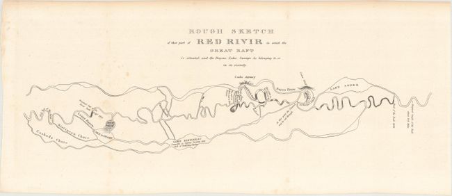
“Rough Sketch of That Part of Red Rivir in Which the Great Raft Is Situated and the Bayous, Lakes, Swamps &c. Belonging to, or in Its Vicinity”
Map Maker:
U.S. Government
This basic map covers the lower Red River and demo... (full text available to subscribers)
| Item Detail |
| |
| |
MapMaker: |
U.S. Government
|
|
| |
| |
Subject: |
Louisiana |
|
| |
Period/Size: |
1834 / 5.8" x 19.0" (14.8 x 48.3 cm)
|
|
| |
Color: |
Black & White
|
|
| |
Condition: |
(B+) Issued folding with a few faint spots of foxing and light toning along the top edge of the sheet. (condition help) |
|
| |
Source: |
H.R. Doc. 98, 23rd Congress, 1st Session |
|
| |
References: |
Phillips (Maps) p. 741. |
|
| |
|
|
| Sales Information |
| |
| |
Price: |
|
|
| |
| |
Offered by: |
Old World Auctions |
|
| |
Catalog: |
Auction No. 165 - Antique Maps, Charts, Atlases & Globes (9380) |
|
| |
Lot/Item #: |
249 |
|
| |
| |
Date: |
11/2017
|
|
| |
| |
|
Antique Maps - Valuation and Pricing, Descriptions, Resources |
|
Home |
Information |
Search |
Register |
Contact Us |
Site Map
Americana Exchange, Inc. © 1999 - 2024 Americana Exchange, Inc.. All rights reserved.
OldMaps.com, the OldMaps.com logo and
AMPR are service marks or registered service marks of Americana Exchange, Inc..
|