Title:
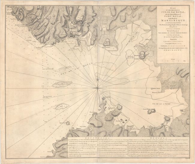
“Plan of the Great Bay of Cul de Sac Royal, with the Town, and Environs of Port Royal, in the Island of Martinique...”
Map Maker:
Thomas Jefferys
This extremely rare map depicts the Bay of Fort-de... (full text available to subscribers)
| Item Detail |
| |
| |
MapMaker: |
Thomas Jefferys
|
|
| |
| |
Subject: |
Fort-de-France Bay, Martinique |
|
| |
Period/Size: |
1765 / 23.1" x 27.9" (58.7 x 70.9 cm)
|
|
| |
Color: |
Black & White
|
|
| |
Condition: |
(B+) On sturdy paper with a large fleur-de-lis watermark, light soiling and minor creasing. (condition help) |
|
| |
Source: |
|
|
| |
References: |
|
|
| |
|
|
| Sales Information |
| |
| |
Price: |
|
|
| |
| |
Offered by: |
Old World Auctions |
|
| |
Catalog: |
Auction No. 165 - Antique Maps, Charts, Atlases & Globes (9380) |
|
| |
Lot/Item #: |
366 |
|
| |
| |
Date: |
11/2017
|
|
| |
| |
|
Antique Maps - Valuation and Pricing, Descriptions, Resources |
|
Home |
Information |
Search |
Register |
Contact Us |
Site Map
Americana Exchange, Inc. © 1999 - 2024 Americana Exchange, Inc.. All rights reserved.
OldMaps.com, the OldMaps.com logo and
AMPR are service marks or registered service marks of Americana Exchange, Inc..
|