Title:
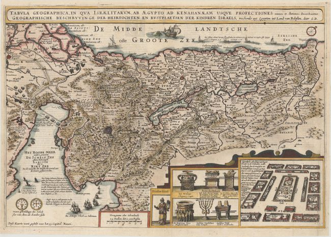
“Tabula Geographica, in qua Israelitarum, ab Aegypto ad Kenahanaeam Usque Profectiones Omnes et Stationes Describuntur. Geographische Beschryvinge der Heirtochten en Rustplaetsen der Kindren Israels...”
Map Maker:
Cornelius Danckerts
This lavishly decorated map of the Holy Land depic... (full text available to subscribers)
| Item Detail |
| |
| |
MapMaker: |
Cornelius Danckerts
|
|
| |
| |
Subject: |
Holy Land |
|
| |
Period/Size: |
1646 / 13.4" x 19.1" (34.1 x 48.6 cm)
|
|
| |
Color: |
Colored
|
|
| |
Condition: |
(A) Issued folding, now flattened on paper with a large fleur-de-lis watermark and a small paper flaw below the title at right. Professionally backed in very thin tissue to lend support and repair a 0.5" centerfold separation at bottom. The top margin h (condition help) |
|
| |
Source: |
|
|
| |
References: |
Laor #792; Poortman & Augusteijn #103. |
|
| |
|
|
| Sales Information |
| |
| |
Price: |
|
|
| |
| |
Offered by: |
Old World Auctions |
|
| |
Catalog: |
Auction No. 165 - Antique Maps, Charts, Atlases & Globes (9380) |
|
| |
Lot/Item #: |
632 |
|
| |
| |
Date: |
11/2017
|
|
| |
| |
|
Antique Maps - Valuation and Pricing, Descriptions, Resources |
|
Home |
Information |
Search |
Register |
Contact Us |
Site Map
Americana Exchange, Inc. © 1999 - 2024 Americana Exchange, Inc.. All rights reserved.
OldMaps.com, the OldMaps.com logo and
AMPR are service marks or registered service marks of Americana Exchange, Inc..
|