Title:
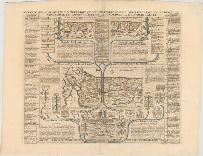
“Carte pour Conduire a l'Inteligence de l'Histoire Sacree, qui Renferme en Abrege la Genealogie, la Geographie, et la Chronologie de l'Histoire Sainte”
Map Maker:
Henry Abraham Chatelain
This folio sheet contains four maps that illustrat... (full text available to subscribers)
| Item Detail |
| |
| |
MapMaker: |
Henry Abraham Chatelain
|
|
| |
| |
Subject: |
Holy Land |
|
| |
Period/Size: |
1719 / 15.7" x 18.4" (39.9 x 46.8 cm)
|
|
| |
Color: |
Colored
|
|
| |
Condition: |
(B+) A nice impression on a sheet with the watermarks of a Strasbourg lily and the initials "C&IH." There is minor toning along the centerfold and a few small holes and separations along the centerfold have been professionally repaired. (condition help) |
|
| |
Source: |
Atlas Historique… |
|
| |
References: |
Laor #210. |
|
| |
|
|
| Sales Information |
| |
| |
Price: |
|
|
| |
| |
Offered by: |
Old World Auctions |
|
| |
Catalog: |
Auction No. 165 - Antique Maps, Charts, Atlases & Globes (9380) |
|
| |
Lot/Item #: |
635 |
|
| |
| |
Date: |
11/2017
|
|
| |
| |
|
Antique Maps - Valuation and Pricing, Descriptions, Resources |
|
Home |
Information |
Search |
Register |
Contact Us |
Site Map
Americana Exchange, Inc. © 1999 - 2024 Americana Exchange, Inc.. All rights reserved.
OldMaps.com, the OldMaps.com logo and
AMPR are service marks or registered service marks of Americana Exchange, Inc..
|