Title:
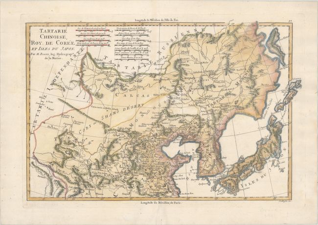
“Tartarie Chinoise, Roy. de Coree et Isles du Japon”
Map Maker:
Rigobert Bonne
This map of China, Korea and Japan only includes n... (full text available to subscribers)
| Item Detail |
| |
| |
MapMaker: |
Rigobert Bonne
|
|
| |
| |
Subject: |
China, Korea & Japan |
|
| |
Period/Size: |
1787 / 9.3" x 14.1" (23.7 x 35.9 cm)
|
|
| |
Color: |
Colored
|
|
| |
Condition: |
(B+) Minor toning along the centerfold with light soiling on paper with the three crescent moons watermark. (condition help) |
|
| |
Source: |
Atlas Encyclopedique... |
|
| |
References: |
|
|
| |
|
|
| Sales Information |
| |
| |
Price: |
|
|
| |
| |
Offered by: |
Old World Auctions |
|
| |
Catalog: |
Auction No. 165 - Antique Maps, Charts, Atlases & Globes (9380) |
|
| |
Lot/Item #: |
661 |
|
| |
| |
Date: |
11/2017
|
|
| |
| |
|
Antique Maps - Valuation and Pricing, Descriptions, Resources |
|
Home |
Information |
Search |
Register |
Contact Us |
Site Map
Americana Exchange, Inc. © 1999 - 2024 Americana Exchange, Inc.. All rights reserved.
OldMaps.com, the OldMaps.com logo and
AMPR are service marks or registered service marks of Americana Exchange, Inc..
|