Title:
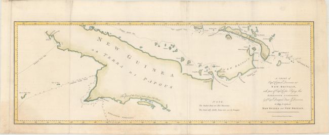
“A Chart of Captn. Carteret's Discoveries at New Britain, with Part of Captn. Cooke's Passage Thro Endeavour Streights, & of Captn. Dampier's Tract of Discoveries in 1699, & 1700, at New Guinea and New Britain”
Map Maker:
William Whitchurch
This sea chart of Papua New Guinea shows the new d... (full text available to subscribers)
| Item Detail |
| |
| |
MapMaker: |
William Whitchurch
|
|
| |
| |
Subject: |
New Guinea |
|
| |
Period/Size: |
1773 / 8.5" x 24.7" (21.6 x 62.8 cm)
|
|
| |
Color: |
Colored
|
|
| |
Condition: |
(B+) Issued folding, now flattened, with some minor extraneous creasing and several faint damp stains entering the image at bottom and far right. (condition help) |
|
| |
Source: |
An Account of the Voyages... |
|
| |
References: |
Shirley (BL Atlases) G.HAWK-1a #14. |
|
| |
|
|
| Sales Information |
| |
| |
Price: |
|
|
| |
| |
Offered by: |
Old World Auctions |
|
| |
Catalog: |
Auction No. 165 - Antique Maps, Charts, Atlases & Globes (9380) |
|
| |
Lot/Item #: |
730 |
|
| |
| |
Date: |
11/2017
|
|
| |
| |
|
Antique Maps - Valuation and Pricing, Descriptions, Resources |
|
Home |
Information |
Search |
Register |
Contact Us |
Site Map
Americana Exchange, Inc. © 1999 - 2024 Americana Exchange, Inc.. All rights reserved.
OldMaps.com, the OldMaps.com logo and
AMPR are service marks or registered service marks of Americana Exchange, Inc..
|