Title:
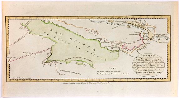
“A Chart of Captain Carteret's Discoveries at New Britain, with Part of Captain Cook's Passage Thro Endeavour Streights, & of Captain Dampier's Tract & Discoveries in 1699, & 1700, at New Guinea & New Britain”
Map Maker:
Thomas Conder
his fine chart of Papua New Guinea shows the new d... (full text available to subscribers)
| Item Detail |
| |
| |
MapMaker: |
Thomas Conder
|
|
| |
| |
Subject: |
East Indies - Indonesia |
|
| |
Period/Size: |
1773 / 6.1" x 14.2" (15.5 x 36.1 cm)
|
|
| |
Color: |
Colored
|
|
| |
Condition: |
In fine condition on hand-made, chain-linked paper. In attractive colours. (condition help) |
|
| |
Source: |
A New Authentic and Complete Collection of Voyages Round the World |
|
| |
References: |
|
|
| |
|
|
| Sales Information |
| |
| |
Price: |
|
|
| |
| |
Offered by: |
Paulus Swaen Old Maps & Prints |
|
| |
Catalog: |
June 26,2018 - Internet Auction (9392) |
|
| |
Lot/Item #: |
96058 |
|
| |
| |
Date: |
06/2018
|
|
| |
| |
|
Antique Maps - Valuation and Pricing, Descriptions, Resources |
|
Home |
Information |
Search |
Register |
Contact Us |
Site Map
Americana Exchange, Inc. © 1999 - 2024 Americana Exchange, Inc.. All rights reserved.
OldMaps.com, the OldMaps.com logo and
AMPR are service marks or registered service marks of Americana Exchange, Inc..
|