Title:
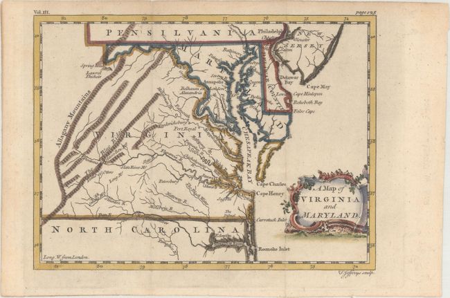
“A Map of Virginia and Maryland”
Map Maker:
Thomas Jefferys
This rare map appeared in Tobias Smollett's A C... (full text available to subscribers)
| Item Detail |
| |
| |
MapMaker: |
Thomas Jefferys
|
|
| |
| |
Subject: |
Colonial Mid-Atlantic United States |
|
| |
Period/Size: |
1756 / 5.8" x 7.8" (14.8 x 19.9 cm)
|
|
| |
Color: |
Colored
|
|
| |
Condition: |
(A) Issued folding on watermarked paper with minor toning along the edges of the sheet. (condition help) |
|
| |
Source: |
A Compendium of Authentic and Entertaining Voyages... |
|
| |
References: |
Maryland State Archives #256J4; cf. Sellers & Van Ee #1391 (Gavin edition); cf. Wooldridge #108 (Gavin edition). |
|
| |
|
|
| Sales Information |
| |
| |
Price: |
|
|
| |
| |
Offered by: |
Old World Auctions |
|
| |
Catalog: |
Auction No. 166 - Antique Maps, Charts, Atlases & Globes (9434) |
|
| |
Lot/Item #: |
145 |
|
| |
| |
Date: |
02/2018
|
|
| |
| |
|
Antique Maps - Valuation and Pricing, Descriptions, Resources |
|
Home |
Information |
Search |
Register |
Contact Us |
Site Map
Americana Exchange, Inc. © 1999 - 2024 Americana Exchange, Inc.. All rights reserved.
OldMaps.com, the OldMaps.com logo and
AMPR are service marks or registered service marks of Americana Exchange, Inc..
|