Title:
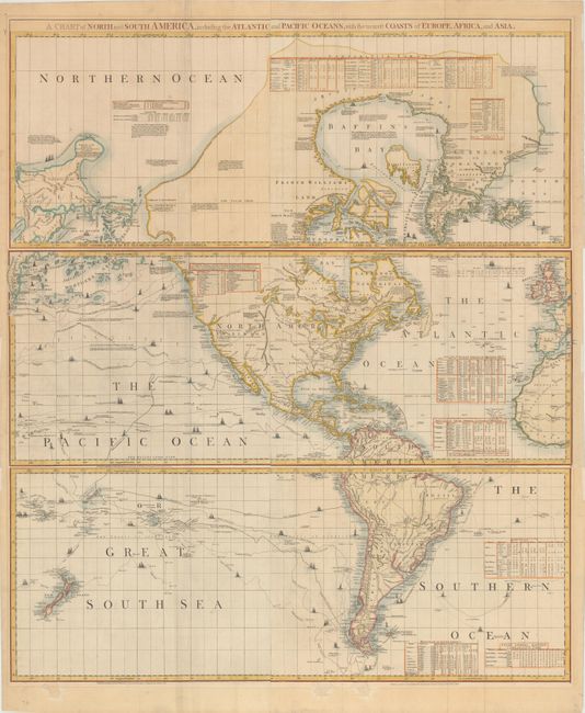
“A Chart of North and South America, Including the Atlantic and Pacific Oceans, with the Nearest Coasts of Europe, Africa, and Asia”
Map Maker:
Jefferys/Sayer & Bennett
This important American map was compiled in 1753 b... (full text available to subscribers)
| Item Detail |
| |
| |
MapMaker: |
Jefferys/Sayer & Bennett
|
|
| |
| |
Subject: |
Western Hemisphere - America |
|
| |
Period/Size: |
1775 / 17.9" x 43.7" (45.5 x 111.0 cm)
|
|
| |
Color: |
Colored
|
|
| |
Condition: |
(B) A nice impression on watermarked paper with three or four 1"-2.5" chips at the bottom of each of the sheets, each repaired with archival materials with portions of the image replaced in facsimile. The northern sheet's chips are in the border and a sm (condition help) |
|
| |
Source: |
The American Atlas |
|
| |
References: |
Ristow pp. 31-32; Schwartz & Erhrenberg, p.158-59; Stevens & Tree #4-Sheet III & IV (d); Wagner (NW) #578 & p. 160 (1st ed.). |
|
| |
|
|
| Sales Information |
| |
| |
Price: |
|
|
| |
| |
Offered by: |
Old World Auctions |
|
| |
Catalog: |
Auction No. 166 - Antique Maps, Charts, Atlases & Globes (9434) |
|
| |
Lot/Item #: |
68 |
|
| |
| |
Date: |
02/2018
|
|
| |
| |
|
Antique Maps - Valuation and Pricing, Descriptions, Resources |
|
Home |
Information |
Search |
Register |
Contact Us |
Site Map
Americana Exchange, Inc. © 1999 - 2024 Americana Exchange, Inc.. All rights reserved.
OldMaps.com, the OldMaps.com logo and
AMPR are service marks or registered service marks of Americana Exchange, Inc..
|