Title:
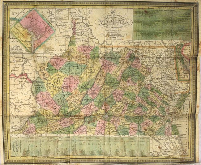
“The Tourist's Pocket Map of the State of Virginia Exhibiting Its Internal Improvements Roads Distances &c.”
Map Maker:
Mitchell/Young
This pocket map of the state shows county developm... (full text available to subscribers)
| Item Detail |
| |
| |
MapMaker: |
Mitchell/Young
|
|
| |
| |
Subject: |
Virginia |
|
| |
Period/Size: |
1837 / 12.4" x 14.9" (31.5 x 37.9 cm)
|
|
| |
Color: |
Colored
|
|
| |
Condition: |
(B) Issued folding with light scattered foxing and a number of fold separations that have been partially repaired on verso with archival tape. Two small areas of loss (Campbell County and Delaware) have been repaired on both recto and verso with archival (condition help) |
|
| |
Source: |
|
|
| |
References: |
|
|
| |
|
|
| Sales Information |
| |
| |
Price: |
|
|
| |
| |
Offered by: |
Old World Auctions |
|
| |
Catalog: |
Auction No. 166 - Antique Maps, Charts, Atlases & Globes (9434) |
|
| |
Lot/Item #: |
292 |
|
| |
| |
Date: |
02/2018
|
|
| |
| |
|
Antique Maps - Valuation and Pricing, Descriptions, Resources |
|
Home |
Information |
Search |
Register |
Contact Us |
Site Map
Americana Exchange, Inc. © 1999 - 2024 Americana Exchange, Inc.. All rights reserved.
OldMaps.com, the OldMaps.com logo and
AMPR are service marks or registered service marks of Americana Exchange, Inc..
|