Title:
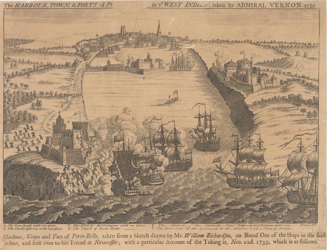
“The Harbour, Town, & Forts of Porto-Bello in ye West Indies; Taken by Admiral Vernon, 1739”
Map Maker:
Henry Overton
This fascinating broadside depicts the Battle of P... (full text available to subscribers)
| Item Detail |
| |
| |
MapMaker: |
Henry Overton
|
|
| |
| |
Subject: |
Portobelo, Panama |
|
| |
Period/Size: |
1740 / 9.6" x 14.1" (24.4 x 35.9 cm)
|
|
| |
Color: |
Black & White
|
|
| |
Condition: |
(B) A nice impression with light toning. There are a number of short tears and one 3.5" tear in the title below the view that have been archivally repaired on verso. Two chips (one in the title at top and one in the title below the view at left) have be (condition help) |
|
| |
Source: |
|
|
| |
References: |
Kapp (MCC-73) #53. |
|
| |
|
|
| Sales Information |
| |
| |
Price: |
|
|
| |
| |
Offered by: |
Old World Auctions |
|
| |
Catalog: |
Auction No. 166 - Antique Maps, Charts, Atlases & Globes (9434) |
|
| |
Lot/Item #: |
328 |
|
| |
| |
Date: |
02/2018
|
|
| |
| |
|
Antique Maps - Valuation and Pricing, Descriptions, Resources |
|
Home |
Information |
Search |
Register |
Contact Us |
Site Map
Americana Exchange, Inc. © 1999 - 2024 Americana Exchange, Inc.. All rights reserved.
OldMaps.com, the OldMaps.com logo and
AMPR are service marks or registered service marks of Americana Exchange, Inc..
|