Title:
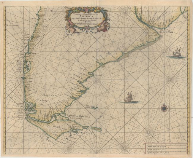
“Paskaarte van 't Zuydelyckste Deel van America, van Cabo St. Antonio, tot Caep de Hoern, en de inde Zuyd-Zee, tot B. de Tongoy”
Map Maker:
Henrick Doncker
Very striking sea chart depicting the southern par... (full text available to subscribers)
| Item Detail |
| |
| |
MapMaker: |
Henrick Doncker
|
|
| |
| |
Subject: |
Southern South America |
|
| |
Period/Size: |
1660 / 16.8" x 21.0" (42.7 x 53.4 cm)
|
|
| |
Color: |
Colored
|
|
| |
Condition: |
(B+) A dark impression with light printer's ink residue, some extraneous creases, and professional repairs to some separations along the centerfold. (condition help) |
|
| |
Source: |
De Zee-Atlas ofte Water-Waerelt |
|
| |
References: |
|
|
| |
|
|
| Sales Information |
| |
| |
Price: |
|
|
| |
| |
Offered by: |
Old World Auctions |
|
| |
Catalog: |
Auction No. 166 - Antique Maps, Charts, Atlases & Globes (9434) |
|
| |
Lot/Item #: |
378 |
|
| |
| |
Date: |
02/2018
|
|
| |
| |
|
Antique Maps - Valuation and Pricing, Descriptions, Resources |
|
Home |
Information |
Search |
Register |
Contact Us |
Site Map
Americana Exchange, Inc. © 1999 - 2024 Americana Exchange, Inc.. All rights reserved.
OldMaps.com, the OldMaps.com logo and
AMPR are service marks or registered service marks of Americana Exchange, Inc..
|