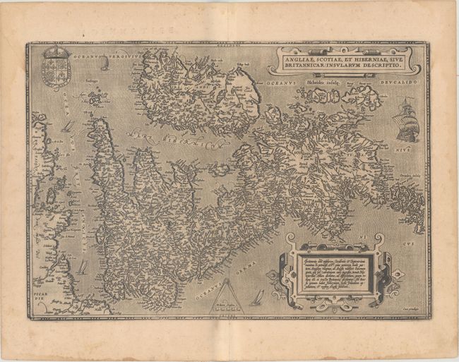
Title:
“Angliae, Scotiae, et Hiberniae, sive Britannicar: Insularum Descriptio”
Map Maker:
Abraham Ortelius
This map, based on the cartography of Gerard Merca... (full text available to subscribers)
| Item Detail |
| |
| |
MapMaker: |
Abraham Ortelius
|
|
| |
| |
Subject: |
Britain |
|
| |
Period/Size: |
1603 / 13.6" x 19.6" (34.6 x 49.8 cm)
|
|
| |
Color: |
Black & White
|
|
| |
Condition: |
(B+) A dark impression on paper with the horn coat of arms commonly found on Ortelius' maps, light toning, a couple of minor printer's creases, and some damp stains along the edges of the sheet. (condition help) |
|
| |
Source: |
Theatrum Orbis Terrarum |
|
| |
References: |
Shirley (MCC-94) #86, pl. 42; Van den Broecke #16. |
|
| |
|
|
| Sales Information |
| |
| |
Price: |
|
|
| |
| |
Offered by: |
Old World Auctions |
|
| |
Catalog: |
Auction No. 166 - Antique Maps, Charts, Atlases & Globes (9434) |
|
| |
Lot/Item #: |
396 |
|
| |
| |
Date: |
02/2018
|
|
| |
| |
|
Antique Maps - Valuation and Pricing, Descriptions, Resources |
|
Home |
Information |
Search |
Register |
Contact Us |
Site Map
Americana Exchange, Inc. © 1999 - 2024 Americana Exchange, Inc.. All rights reserved.
OldMaps.com, the OldMaps.com logo and
AMPR are service marks or registered service marks of Americana Exchange, Inc..
|