Title:
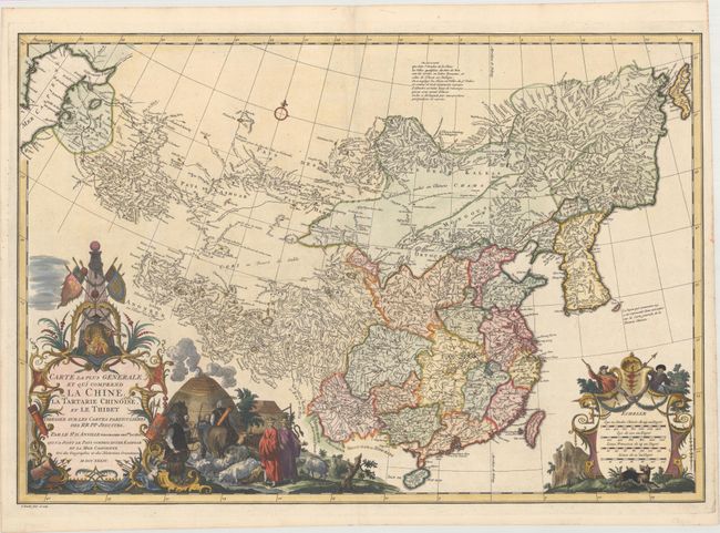
“Carte la Plus Generale et qui Comprend la Chine, la Tartarie Chinoise, et le Thibet Dressee sur les Cartes Particulieres des RR PP Jesuites”
Map Maker:
Du Halde/D'Anville
A lovely copper engraved map that covers all of Ch... (full text available to subscribers)
| Item Detail |
| |
| |
MapMaker: |
Du Halde/D'Anville
|
|
| |
| |
Subject: |
China & Korea |
|
| |
Period/Size: |
1734 / 18.6" x 27.3" (47.3 x 69.4 cm)
|
|
| |
Color: |
Colored
|
|
| |
Condition: |
(A) Superb impression with minor toning along the edges of the sheet. (condition help) |
|
| |
Source: |
Description Geographique Historique... de l'Empire de la Chine... |
|
| |
References: |
Shirley (BL Atlases) T.HALD-1a #1. |
|
| |
|
|
| Sales Information |
| |
| |
Price: |
|
|
| |
| |
Offered by: |
Old World Auctions |
|
| |
Catalog: |
Auction No. 166 - Antique Maps, Charts, Atlases & Globes (9434) |
|
| |
Lot/Item #: |
663 |
|
| |
| |
Date: |
02/2018
|
|
| |
| |
|
Antique Maps - Valuation and Pricing, Descriptions, Resources |
|
Home |
Information |
Search |
Register |
Contact Us |
Site Map
Americana Exchange, Inc. © 1999 - 2024 Americana Exchange, Inc.. All rights reserved.
OldMaps.com, the OldMaps.com logo and
AMPR are service marks or registered service marks of Americana Exchange, Inc..
|