Title:
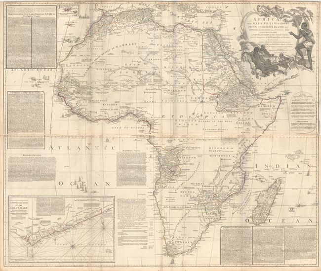
“Africa, with All Its States, Kingdoms, Republics, Regions, Islands, &ca. Improved and Inlarged from d'Anville's Map; to Which Have Been Added a Particular Chart of the Gold Coast…”
Map Maker:
Laurie & Whittle
A superb, four-sheet map based on the cartography ... (full text available to subscribers)
| Item Detail |
| |
| |
MapMaker: |
Laurie & Whittle
|
|
| |
| |
Subject: |
Africa |
|
| |
Period/Size: |
1794 / 20.4" x 47.9" (51.9 x 121.7 cm)
|
|
| |
Color: |
Colored
|
|
| |
Condition: |
(B+) Original outline color on watermarked paper, issued folding. There is light soiling, some toning along the folds and edges of the sheet, and a few short fold separations also along the edges of the sheet. A 2" tear at top left has been archivally r (condition help) |
|
| |
Source: |
|
|
| |
References: |
|
|
| |
|
|
| Sales Information |
| |
| |
Price: |
|
|
| |
| |
Offered by: |
Old World Auctions |
|
| |
Catalog: |
Auction No. 166 - Antique Maps, Charts, Atlases & Globes (9434) |
|
| |
Lot/Item #: |
691 |
|
| |
| |
Date: |
02/2018
|
|
| |
| |
|
Antique Maps - Valuation and Pricing, Descriptions, Resources |
|
Home |
Information |
Search |
Register |
Contact Us |
Site Map
Americana Exchange, Inc. © 1999 - 2024 Americana Exchange, Inc.. All rights reserved.
OldMaps.com, the OldMaps.com logo and
AMPR are service marks or registered service marks of Americana Exchange, Inc..
|