Title:
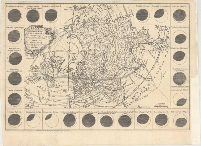
“The Geography of the Great Solar Eclipse of July 14, MDCCXLVIII. Exhibiting an Accurate Map of All Parts of the Earth in Which It Will Be Visible with the North Pole According to the Latest Discoveries”
Map Maker:
Thomas Jefferys
This fascinating map charts the geographical path ... (full text available to subscribers)
| Item Detail |
| |
| |
MapMaker: |
Thomas Jefferys
|
|
| |
| |
Subject: |
Northern Hemisphere |
|
| |
Period/Size: |
1748 / 12.0" x 17.4" (30.5 x 44.2 cm)
|
|
| |
Color: |
Black & White
|
|
| |
Condition: |
(A) A crisp impression issued folding, now flat, laid on sturdy paper. There is a binding trim and associated tiny tear at right. (condition help) |
|
| |
Source: |
Gentleman's Magazine |
|
| |
References: |
Jolly #GENT-59. |
|
| |
|
|
| Sales Information |
| |
| |
Price: |
|
|
| |
| |
Offered by: |
Old World Auctions |
|
| |
Catalog: |
Auction No. 167 - Antique Maps, Charts, Atlases & Globes (9435) |
|
| |
Lot/Item #: |
23 |
|
| |
| |
Date: |
03/2018
|
|
| |
| |
|
Antique Maps - Valuation and Pricing, Descriptions, Resources |
|
Home |
Information |
Search |
Register |
Contact Us |
Site Map
Americana Exchange, Inc. © 1999 - 2024 Americana Exchange, Inc.. All rights reserved.
OldMaps.com, the OldMaps.com logo and
AMPR are service marks or registered service marks of Americana Exchange, Inc..
|