Title:
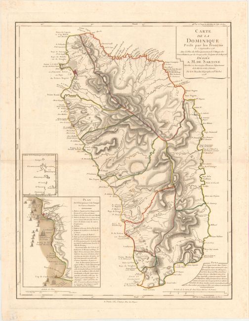
“Carte de la Dominique Prise par les Francois le 7 Septembre 1778. Avec le Plan du Debarquement, et de l'Attaque des Forts et Batteries par les Troupes et les Fregates de sa Majeste...”
Map Maker:
Philip Buache
This large, detailed map of the island of Dominica... (full text available to subscribers)
| Item Detail |
| |
| |
MapMaker: |
Philip Buache
|
|
| |
| |
Subject: |
Dominica |
|
| |
Period/Size: |
1778 / 23.8" x 18.6" (60.5 x 47.3 cm)
|
|
| |
Color: |
Colored
|
|
| |
Condition: |
(B+) Nice impression and full contemporary color with some light scattered foxing and minor toning along the centerfold. The ink from a manuscript note in the blank margin at bottom left has oxidized and damaged the paper, now repaired with tissue. (condition help) |
|
| |
Source: |
|
|
| |
References: |
Sellers & Van Ee #2041; Tooley (MCC-62) #9. |
|
| |
|
|
| Sales Information |
| |
| |
Price: |
|
|
| |
| |
Offered by: |
Old World Auctions |
|
| |
Catalog: |
Auction No. 167 - Antique Maps, Charts, Atlases & Globes (9435) |
|
| |
Lot/Item #: |
226 |
|
| |
| |
Date: |
03/2018
|
|
| |
| |
|
Antique Maps - Valuation and Pricing, Descriptions, Resources |
|
Home |
Information |
Search |
Register |
Contact Us |
Site Map
Americana Exchange, Inc. © 1999 - 2024 Americana Exchange, Inc.. All rights reserved.
OldMaps.com, the OldMaps.com logo and
AMPR are service marks or registered service marks of Americana Exchange, Inc..
|