Title:
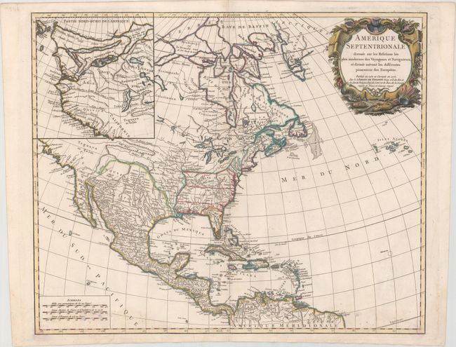
“Amerique Septentrionale Dressee sur les Relations les Plus Modernes des Voyageurs et Navigateurs, et Divisee Suivant les Differentes Possessions des Europeens”
Map Maker:
Didier Robert de Vaugondy
The colonial possessions are well defined on this ... (full text available to subscribers)
| Item Detail |
| |
| |
MapMaker: |
Didier Robert de Vaugondy
|
|
| |
| |
Subject: |
Colonial North America |
|
| |
Period/Size: |
1775 / 19.0" x 23.2" (48.3 x 59.0 cm)
|
|
| |
Color: |
Colored
|
|
| |
Condition: |
(B+) A crisp impression on watermarked paper with faint damp stains in corners and some light, small mildew stains at bottom. (condition help) |
|
| |
Source: |
Atlas Universel |
|
| |
References: |
Pedley #448. |
|
| |
|
|
| Sales Information |
| |
| |
Price: |
|
|
| |
| |
Offered by: |
Old World Auctions |
|
| |
Catalog: |
Auction No. 167 - Antique Maps, Charts, Atlases & Globes (9435) |
|
| |
Lot/Item #: |
51 |
|
| |
| |
Date: |
03/2018
|
|
| |
| |
|
Antique Maps - Valuation and Pricing, Descriptions, Resources |
|
Home |
Information |
Search |
Register |
Contact Us |
Site Map
Americana Exchange, Inc. © 1999 - 2024 Americana Exchange, Inc.. All rights reserved.
OldMaps.com, the OldMaps.com logo and
AMPR are service marks or registered service marks of Americana Exchange, Inc..
|