Title:
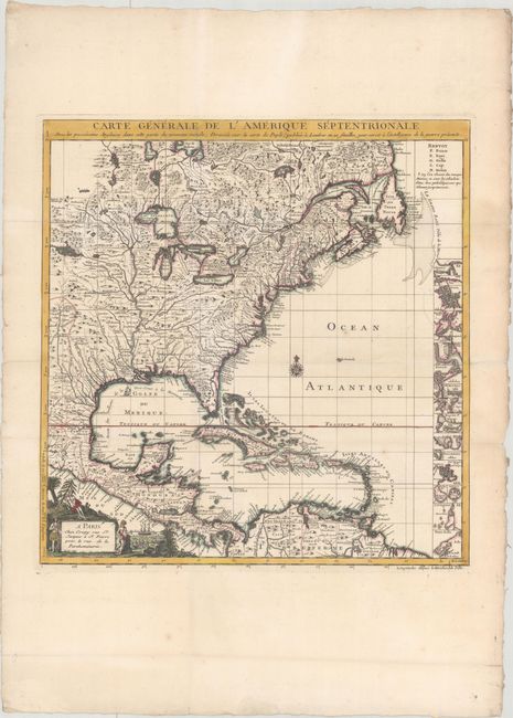
“Carte Generale de l'Amerique Septentrionale avec les Possessions Angloises dans Cette Partie du Nouveau Monde, Dressee sur la Carte de Pople...”
Map Maker:
Crepy [Family]
This is the French edition of Popple's key map of ... (full text available to subscribers)
| Item Detail |
| |
| |
MapMaker: |
Crepy [Family]
|
|
| |
| |
Subject: |
Colonial Eastern North America & West Indies |
|
| |
Period/Size: |
1756 / 20.2" x 19.4" (51.3 x 49.3 cm)
|
|
| |
Color: |
Colored
|
|
| |
Condition: |
(A) Issued folding on watermarked paper with professional repairs to a few tiny holes at fold intersections. The folds have also been professionally reinforced on verso. A minor abrasion in the border at right has also been archivally repaired. (condition help) |
|
| |
Source: |
|
|
| |
References: |
McCorkle #742.2. |
|
| |
|
|
| Sales Information |
| |
| |
Price: |
|
|
| |
| |
Offered by: |
Old World Auctions |
|
| |
Catalog: |
Auction No. 167 - Antique Maps, Charts, Atlases & Globes (9435) |
|
| |
Lot/Item #: |
59 |
|
| |
| |
Date: |
03/2018
|
|
| |
| |
|
Antique Maps - Valuation and Pricing, Descriptions, Resources |
|
Home |
Information |
Search |
Register |
Contact Us |
Site Map
Americana Exchange, Inc. © 1999 - 2024 Americana Exchange, Inc.. All rights reserved.
OldMaps.com, the OldMaps.com logo and
AMPR are service marks or registered service marks of Americana Exchange, Inc..
|