Title:
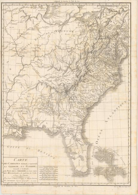
“Carte des Carolines Meridionale et Septentrionale, la Georgie, la Floride, Orientale et Occidentale, le Pays des Cherokees, la Vaste Contree des Muscogulges, ou la Confederation des Creks et Pays des Chataws”
Map Maker:
Jean Baptiste Poirson
This map is from a French edition of William Bartr... (full text available to subscribers)
| Item Detail |
| |
| |
MapMaker: |
Jean Baptiste Poirson
|
|
| |
| |
Subject: |
Eastern United States |
|
| |
Period/Size: |
1799 / 24.3" x 17.4" (61.8 x 44.2 cm)
|
|
| |
Color: |
Black & White
|
|
| |
Condition: |
(B) Issued folding on watermarked paper with light scattered foxing and one short fold separation along the left border that has been closed on verso with archival material. There is a narrow left margin. (condition help) |
|
| |
Source: |
Voyage dans les Parties Sud de l'Amerique Septentrionale... |
|
| |
References: |
Howes #B223; Sabin #3871; Streeter Sale #1088. |
|
| |
|
|
| Sales Information |
| |
| |
Price: |
|
|
| |
| |
Offered by: |
Old World Auctions |
|
| |
Catalog: |
Auction No. 167 - Antique Maps, Charts, Atlases & Globes (9435) |
|
| |
Lot/Item #: |
88 |
|
| |
| |
Date: |
03/2018
|
|
| |
| |
|
Antique Maps - Valuation and Pricing, Descriptions, Resources |
|
Home |
Information |
Search |
Register |
Contact Us |
Site Map
Americana Exchange, Inc. © 1999 - 2024 Americana Exchange, Inc.. All rights reserved.
OldMaps.com, the OldMaps.com logo and
AMPR are service marks or registered service marks of Americana Exchange, Inc..
|